

Edinburgh City Wall
The Flodden Wall and Telfer Wall
Flodden Wall Route
The Flodden and Telfer Walls
Where the Ports (Gates) of Edinburgh once stood.
The Edinburgh City Wall, The Flodden and Telfer Wall, plus where the Ports or gateways into Edinburgh stood.
The first Edinburgh city wall was erected circa 1450 (The King’s Wall) James III. A marsh in the hollow below the castle to the north was flooded in 1460 which with the wall completed the defence for the Castle and the
Old Town of Edinburgh.
It was fortified and extended in 1513 after the Battle of Flodden.
A further extension to the Edinburgh city wall was built to include Heriot’s Hospital (school) circa 1630.
There was also a wall that extended to the Palace of Holyrood to surround the Canongate area, but this was not considered as a protection as was out with the city wall.
Edinburgh City Wall
Route of Flodden Wall and Telfer Wall on Google map
Red markers are the Ports (Gates) Black markers wall Towers
(Blue Line Flodden Wall) (Brown Line Telfer Wall)
Yellow markers place of interest which can be seen with history throughout the website.

Edinburgh City Walls Route and Map Ports – Gates 8 ports
West Port | New Port | Bristo Port | Kirk O Fields Port known later as Potterrow Port | St Mary’s Port
Cowgate Port | Nether Bow Port | Leith (Lytht) Port.
Edinburgh Castle
(David’s Tower) Half-Moon Battery
Johnstone Terrace
(Granny Green Steps) (King’s Wall Plaque)
Grassmarket
(Walter Scott Poem)
West Port
(Vennel Steps) (Flodden Wall)
(Flodden Tower)
Heriot Place
(Telfer Wall)
Lauriston Place
(Telfer Wall)
Forrest Road
(New Port) (Bristo Gate Plaque + Setts)
Bristo Place
(Bristo Port - (Telfer City Wall Carving)
West College Street
(Kirk O Fields Port) Later (Potterrow Port)
Drummond Street
(Flodden Wall)
Pleasance
(Flodden Wall and Plaque) (St Mary's Port)
Cowgate
(Cowgate Port)
High Street
(Nether Bow Port) (Brass Setts)
Leith (Lytht) Wynd
(Trinity Church) (Lytht Port)
Jeffrey Street - View
Calton Hill - Jail Wall - Wall End - Nor’ Loch
Tweeddale Court
(King’s Wall) (Outlander)
Storytelling Centre
(Nether Bow Plaque)
(Nether Bow Bell)
Edinurgh City wall Start
David’s Tower | Half Moon Battery
King David II, son of Robert the Bruce rebuilt Edinburgh Castle with stone and added a tower in the 1380’s.
David’s Tower was used as the royal residence. Also a secure place for valuables and regalia.
It was a lookout Tower of 100 ft (40 mtrs) plus in height with 360 degree views and canon for when under attack.
A castle stronghold. It was destroyed by a bombardment by the English after the Lang Siege in 1573. A few years later the Half-Moon Battery was built in its place. The discovery of remnants of David’s Tower were uncovered in 1912 within the half-moon battery.


Edinburgh City Wall
House at top of Granny Green Steps on Johnston Terrace (First City Wall) and steps to the Grassmarket route of Flodden Wall.
Inscription; Erected on a site near the extremity of the ancient town wall
built in the reign of James II King of Scots A.D. 1450 for the protection of Edinburgh against invasion.


Castle Wynd South
Castle Wynd South is a path and steps that gives access to Johnston Terrace from the Grassmarket. Originally a medieval (1400’s) thoroughfare wide enough to allow livestock and carts to be moved from the castle down to the cattle and horse markets in the Grass Market. The arch is believed to be entrance to a cellar of an old store. The old wall at the back is believed to be the King’s Wall (1450) the first wall protecting Edinburgh.
Inscription: W1 D No X11 6 FT 6 INS FROM WALL
W1 D: Stands for War Department, No X11: identifying number pipe, or boundary point (11th in a series).
6 FT 6 INS FROM WALL: Provides the precise, measured distance from the stone to a structural ancient wall.


Edinburgh City Wall - Flodden Wall
The paving stones mark where the Flodden Wall stood across the Grassmarket from Granny Green Steps.
The inscription on the slabs are a poem by Sir Walter Scott (Marmion) about the Flodden Battle in 1513.
On September 9, 1513, a battle between Scotland and England took place on Flodden Field, Branxton Moor.
The English army lead by The Earl of Surry (Thomas Howard) defeated The Scots and the death of
King James IV of Scotland the last monarch to die in Battle.
Edinburgh City Wall - Flodden Wall
Walter Scott's Poem (Marmion)
The Battle of Flodden 1513

From Flodden ridge,
The Scots beheld the English host
Leave Barmoor Wood, their evening post
And headful watched them as they crossed
The Till by Twizell Bridge.

High sight it is, and haughty, while
They dive into the deep defile;
Beneath the cavern’d cliff they fall,
Beneath the castle’s airy wall.

By rock, by oak, by Hawthorn tree,
Troop after troop are disappearing;
Troop after troop their banners rearing
Upon the eastern bank you see.

Still pouring down the rocky glen,
Where flows the sullen Till,
And rising from the dim-wood glen,
Standards on standards, men on men,
In slow procession still,

And sweeping o’er the Gothic arch,
And pressing on in ceaseless march,
To gain the opposing hill.

Sir Walter Scott
1771 - 1832

The marker where the Flodden Wall
stood across the Grassmarket

The marker where the Flodden Wall and West Port Gate
stood at the foot of the Vennel Steps
The Salvation Army Women’s Hostel
West Port
The Salvation Army Women’s Hostel stands beside the Vennel and the site of the West Port Gate at the west end of the Grassmarket since 1911. The area on the right was known as Portsburgh evidence still remains with street signs.


The Vennel Steps, now have been renamed Miss Jean Brodie Steps, that access to the Flodden Tower. The Paving Stone at the foot of the steps is where the West Port Gate would have stood.


Edinburgh City Wall Flodden Tower
The Flodden Wall this is the only remaining lookout tower of the Flodden wall.
It is also where a wall to protect Heriot’s Hospital (school) joined the Flodden wall.

Edinburgh City Wall
Flodden Tower Window
The window in the Flodden Tower.
A double window was inserted in the wall by the town council in 1876,
now blocked.
The inscription reads;
THIS WINDOW WAS MADE IN THE OLD CITY WALL WITH THE SANCTION OF THE TOWN COUNCIL 1876

Edinburgh City - Wall Telfer Wall
The Telfer Wall in Heriot Place with Edinburgh Castle in the background.
This has become a favourite viewpoint of Edinburgh Castle for visitors to Edinburgh

Edinburgh City - Wall Telfer Wall
The Telfer Wall at the corner of Heriot Place and Lauriston Place

Edinburgh City - Wall Telfer Wall
The last part of the Telfer Wall still standing (Lauriston Place).
Behind the wall was the Covenanter’s Prison. (Access in Greyfriars Graveyard)

Edinburgh City Wall
Flodden Wall Plaque
New Port (Gate)
Flodden Plaque and Setts (cobbles) show near to where a Port stood (See map above) before Forrest Road was built and the Port was part of Grayfriars. The Bristo Port was at Bristo Street now Place at side of the Museum. This was a contnuation of the Flodden wall from the Vennel Tower.
A section of the Flodden wall pictured below that still stands in Grayfriars burial ground.
The Telfer Wall continued along Teviot Place see sign above to Napiers where it rejoined the Flodden Wall.


Edinburgh City Wall Flodden Wall
Bristo Port (Gate)
Bristo Place Edinburgh
Bristo Place previously Bristo Street, which was linked to Potterrow one of the main thoroughfares.
This road gave access to Edinburgh from the south, before the Southbridge and Forrest Road had been built. Bristo Street is where the Darien House was sited and the Edinburgh Asylum in an area triangle called Bedlam. The asylum closed in 1841 (one of the patients was Robert Fergusson the poet).
The Triangle was demolished when Forest Road was built IN 1872 and Bristo Street became Bristo Place.


Edinburgh City Wall Telfer Wall
Wall Tablet above Napier's The Herbalist Bristo Place


Edinburgh City Wall
Kirk O Field Port
The Kirk O Field Port was at West College Street where the yellow line begins then a left turn into South College Street continue down Drummond Street left turn into Pleasances
see diagram the x are where the body of Lord Darnley was found under a tree in
Blackfriars Monastery grounds.


The origin Infirmary Gates that stood in High School Yards in Infirmary Street 1830.

The Flodden Wall in Drummond Street turning into the Pleasance Edinburgh.
Where there is an old bricked up gateway for entrance to Edinburgh.
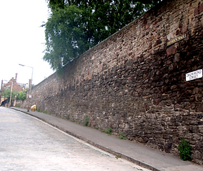

The final part of the Flodden Wall that still stands at the foot of St Mary's Street Edinburgh.


The final part of the Flodden Wall that still stands at the foot of St Mary's Street Edinburgh.
The Cowgate Port stood across the entrance to the Cowgate and St Mary's Port across the Pleasance
two of eight Ports (Gates).
Cowgate Port

St Mary's Port

Edinburgh City Wall Nether Bow Port
The brass cobbles showing the outline of where the Nether Bow Port (Gate) stood.
On the boundary of Edinburgh and outside the walls a baron area before the Burgh of the Canongate.
The Nether Bow was the most important gateway as it stood at the foot of the High Street.
The port (Gate) access to and from the Canongate, which was at that time a separate Burgh.


Leith (Leytht) Port
Leith Port is the last Port of the Flodden Wall.
The wall stretched from the Nether Bow Port to the shore of the Nor' Loch beside The Trinity College Church.
Edinburgh's Trinity Apse Church stood below the Calton Jail Wall and next to the Nor' Loch.
The Church was moved when the Waverley Rail Station was built. It was dismantled brick by brick and rebuilt in
Chalmer's Close in the High Street Royal Mile.


Calton Hill from Jeffrey Street looking over where the end of the Flodden Wall stood and the shore of the Nor Loch beside the Trinity Church which is now in Chalmer's Close.

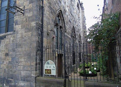
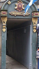
Tweeddale Court
The wall in Tweeddale Court may represent part of the original city wall as the city gates (Nether Bow Port) were originally higher up the High Street near Tweeddale Court before The Burning of Edinburgh in 1544 by an English army lead by Hertford. The gate was almost destroyed the gate was rebuilt in 1606.
The other part of the king's Wall that still remains is in the Grassmarket.
All that remains are parts of the wall, the gates (ports) were all removed in 1764.
The clock that was a centre piece of the Nether Bow Port can now be seen on the
Modern Art Gallery 2 (Dean Gallery) in Belford Road.
The bell that hung on the Port from 1621 and a carved stone plaque from 1606 be seen at the Storytelling Centre where the old gate once stood.
Tweeddale Court High Street king's Wall 1450

.jpg)
Nether Bow
High Street Royal Mile
Edinburgh City Gates.
There were walls around the city of Edinburgh with gates known as Ports, 8 in all. In the 1700s the demolition of sections of the wall began. The Nether Bow was pulled down in 1764, and demolition of the wall continued into the 19th century. Today, a number of sections of the three successive walls survive, The New Port in Grayfriars is the only Port that remains. You can see and find out more about Edinburgh’s history in the Museum of Edinburgh in the Canongate.
Nether Bow Plaque and Nether Bow Bell


The Clock from The Nether Bow Port on the Dean Gallery Belford Road.

